
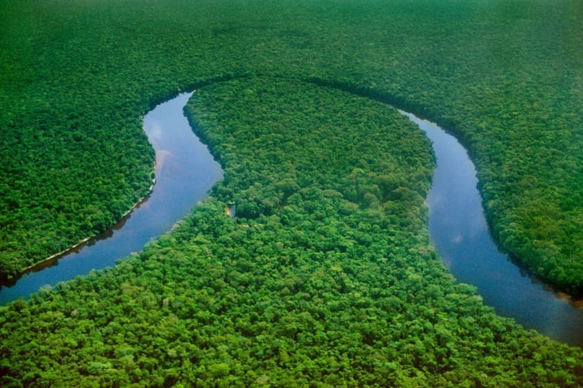
Geography of the DRC
A continental-scale landscape spanning 2.3 million km² — from the world's deepest river to Africa's most active volcanoes
The Democratic Republic of the Congo is Africa's second-largest country, straddling the equator across 2,344,858 km². Its territory encompasses the world's second-largest rainforest, the planet's deepest river, active volcanoes, glacial peaks, vast savannas, and the shores of Africa's Great Lakes. No single country on Earth contains such geographic diversity.
2.34M km²
Total Area
4,700 km
Congo River Length
5,109 m
Highest Peak
26
Provinces
Rivers and Waterways
The Congo River dominates the country's geography. At 4,700 km, it is Africa's second-longest river and the world's deepest — plunging over 220 metres near Kinshasa. Its drainage basin of 3.7 million km² is second only to the Amazon, and its discharge rate makes it the world's second-most-powerful river by volume.
Major tributaries include the Kasai (flowing from Angola), the Lualaba (the Congo's upper course, rising in Katanga), the Ubangi (forming part of the northern border), and the Lomami, which flows through the recently established Lomami National Park. The Lualaba River features the spectacular Boyoma Falls — a series of seven cataracts near Kisangani that constitute the world's largest waterfall by volume.
Lake Tanganyika, shared with Tanzania, Burundi, and Zambia, is the world's longest freshwater lake (673 km) and second-deepest (1,470 m). Lake Kivu, Lake Edward, and Lake Albert line the Eastern Rift, forming some of the most scenic landscapes in Central Africa.
Mountains and Volcanoes
The eastern edge of the DRC is defined by the Albertine Rift — the western branch of the East African Rift System. This geological corridor contains some of Africa's most dramatic peaks:
Rwenzori Mountains
The legendary 'Mountains of the Moon' rise to 5,109 m at Margherita Peak — Africa's third-highest summit. Glacial peaks, giant heather forests, and unique alpine flora make this a world-class trekking destination.
Mount Nyiragongo (3,470 m)
One of Africa's most active volcanoes, famous for its persistent lava lake — one of only four on Earth. Night treks to the summit offer one of the continent's most extraordinary experiences.
Mount Nyamuragira (3,058 m)
Africa's most active volcano by eruption frequency. Located in Virunga National Park alongside Nyiragongo, it has erupted more than 30 times since 1882.
Mitumba Mountains
A chain running along the western shore of Lake Tanganyika, separating the Congo Basin from the East African plateau. Home to Kahuzi-Biéga National Park and the eastern lowland gorilla.
The 26 Provinces
The 2006 Constitution reorganised the DRC from 11 provinces into 25 provinces plus the capital city Kinshasa. Each province offers distinct landscapes, cultures, and tourism potential:
Eastern Highlands
Provinces: North Kivu, South Kivu, Maniema, Ituri, Haut-Uélé
Highlights: Virunga volcanoes, gorilla habitat, Great Lakes, Okapi Wildlife Reserve
Central Basin
Provinces: Tshopo, Mongala, Équateur, Tshuapa, Mai-Ndombe
Highlights: Congo Basin rainforest, Lomami National Park, Boyoma Falls
Southern Savanna
Provinces: Haut-Katanga, Lualaba, Haut-Lomami, Tanganyika
Highlights: Upemba National Park, Lake Tanganyika, copper belt mining heritage
Western Corridor
Provinces: Kinshasa, Kongo Central, Kwilu, Kwango
Highlights: Congo River mouth, Atlantic coast, Zongo Falls, Lola ya Bonobo
Climate Zones
Straddling the equator, the DRC experiences three distinct climate zones that shape its ecosystems and travel seasons:
Equatorial
Temperature: 24–28°C year-round
Rainfall: 1,800–2,500 mm/year
Hot, humid, with rainfall throughout the year. Covers the central Congo Basin. No distinct dry season in the deepest equatorial belt.
Tropical Savanna
Temperature: 22–30°C
Rainfall: 1,000–1,600 mm/year
Distinct wet (Oct–Apr) and dry (May–Sep) seasons. Covers the southern plateau and northern savannas. Ideal for wildlife viewing during the dry season.
Mountain / Highland
Temperature: 10–20°C
Rainfall: 1,200–2,000 mm/year
Cool to temperate conditions in the eastern highlands above 1,500 m. Night temperatures can drop below 5°C. Gorilla trekking regions enjoy pleasant daytime weather year-round.
Major Ecosystems
- Congo Basin Rainforest — the world's second-largest tropical rainforest, spanning over 1 million km² within the DRC. Home to forest elephants, bonobos, okapi, and over 10,000 plant species.
- Albertine Rift Montane Forests — among the most biodiverse regions on Earth, harbouring mountain gorillas, eastern lowland gorillas, and over 50% of Africa's bird species.
- Miombo Woodland Savanna — vast deciduous woodlands across the southern provinces, supporting large mammal populations and traditional pastoral communities.
- Freshwater Systems — the Congo River basin contains the highest freshwater fish diversity in Africa, with over 700 species, many found nowhere else.
- Afro-alpine Zones — above 3,500 m in the Rwenzori Mountains, unique giant groundsel and lobelia plants create an otherworldly landscape.
Frequently Asked Questions
How big is the Democratic Republic of the Congo?
The DRC covers 2,344,858 km² — roughly the size of Western Europe. It is Africa's second-largest country by area and the 11th-largest in the world.
What are the major rivers in the DRC?
The Congo River is the world's second-longest river in Africa (4,700 km) and the deepest in the world (over 220 metres). Major tributaries include the Kasai, Lualaba, Ubangi, Lomami, and Aruwimi rivers.
What is the highest mountain in the DRC?
Mount Stanley (Margherita Peak) in the Rwenzori Mountains reaches 5,109 metres, making it Africa's third-highest peak. The DRC also has active volcanoes including Nyiragongo (3,470 m) and Nyamuragira.
How many provinces does the DRC have?
The DRC is divided into 25 provinces plus the capital city Kinshasa, totalling 26 administrative regions. These span tropical rainforest, savanna, mountain, and lake ecosystems.
What climate zones exist in the DRC?
The DRC spans equatorial, tropical, and mountain climates. The equatorial zone receives over 2,000 mm of rainfall annually, while the southern savanna has distinct wet and dry seasons. Highland areas in the east enjoy temperate conditions year-round.